 Polski
 Deutsch
 Slovenský
distance (km)
altitude m a.s.l.
Educational,
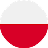
drogowskazy
10,9 km
4h 15min
↗
552 m
↘
506 m
 Zatwarnica
  Potok Hyrlaty