
 Polski
 Deutsch
 Slovenský
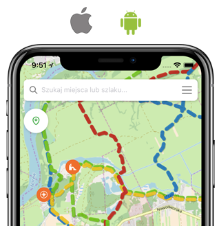
Słonne Mountains Landscape Park was established in 1992 and currently covers an area of 56,188 ha. It is situated in the communities: Lesko, Olszanica, Sanok, Tyrawa Wołoska and Ustrzyki Dolne. The park includes in its area typical of the Eastern Carpathians mountain ranges: the Słonne Mountains and Chwaniowa. The mountains ridges formed grate-liked from the north-west to the southeast are intersected by a network of rivers and streams that are tributaries of the San and Wiar Rivers. Through the south-eastern part of the Park passes the border of the main European water divide, separating the catchment of the Baltic Sea from the catchment of the Black Sea. The waters to the Black Sea from Poland are collected by the Strwiąż River, which falls into the Dniestr River.
The name of the park derives from salty springs. Stanisław Staszic wroteaboutthem in his work "O ziemiorództwie Karpatów i innych gór i równin Polski”. Their significant density is located within Na Opalonym peak. 78 counted streams which drain waters of different salt content degree. There are also petroleum deposits. Just before the World War II, 70 wells with an average depth of 300 m were established in the area of Ropienki. At present, the deposits run out already. The park area is 73% forested, mainly by a Carpathian beechmast. The dendrological oddity of the Park are woody forms of the yew occurring in the proximity of Serednica and the position of the shrub – green alder in the proximity of Bandrow, while geological - discoveries of the Carpathian flysch straggled throughout its territory. Particularly precious places have been protected in the form of a reserve, there are 9 of such places.
